How Healthy Are Our Watersheds?
Ways to Protect Our Watersheds
Stream Buffers
-Riparian Buffer & Rain Garden
-Buffer Handbook
-Sources of native plants
Upper Thornton River Watershed Study
RappFLOW is a member of the Orion Grassroots Network
Rappahannock County Natural Resource Map Series
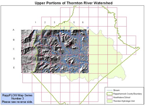
Map Number 3: Thornton Upper Watershed
This map shows topography and streams in a portion of the upper Thornton River Watershed in Rappahannock County, Virginia. The thirty grid cells A1 through E6 were each enlarged and printed on a separate sheet of paper, and then pasted together by students at Hearthstone School, to create a large scale topographic map. The students used the larger map to analyze topological patterns as part of their study of the upper Thornton and sources of erosion and sedimentation.
The large, pale green polygon represents the Thornton Hydrologic Unit. This shows that the Upper Thornton is the largest sub-watershed in the County.
This map was constructed using 10-meter resolution Digital Elevation Models (DEMs) of the area. The 3-D appearance of the mountains is enhanced through a hillshading technique using Geographic Information System (GIS) software. The streams layer superimposed on the terrain is taken from the Digital Line Graphs (DLG) from the Virginia Base Mapping System. Altogether, over 100 separate digital files were used to create this map.
The Rappahannock County Natural Resource Map Series is designed to assist citizens and leaders in Rappahannock County, Virginia, in understanding and making decisions about uses and protection of natural resources in this scenic, rural area. Each map in the series addresses a separate theme, such as streams, watersheds, riparian buffers, water quality, topography, land cover and land use, land conservation, historic districts, rustic roads, and others. This map series is produced by the Piedmont Research Institute as a public service, with support from several organizations including the Rappahannock County Government, Rappahaynnock League for Environmental Protection, Piedmont Environmental Council, Rappahannock Friends and Lovers of Our Watershed (RappFLOW), the Rappahannock County Conservation Alliance, National Fish and Wildlife Foundation, and others. You can obtain maps in this series by attending RappFLOW events. Contact: rappflow@earthlink.net
Map Number 1: Major Streams
(See RappFLOW Reports & Publications:
Air and Water Quality in the Shenandoah National Park)
Map Number 2: Streamside Vegetation
(See Ways to Protect Our Watershed:
Streamside Vegetation)
Map Number 3: Thornton Upper
Watershed
(See Ways to Protect Our Watershed:
Stop Erosion Now!)
Map Number 4: Forests and Streams
(See Ways to Protect our Watershed:
Sustainable Forestry)

