How Healthy Are Our Watersheds?
Ways to Protect Our Watersheds
Stream Buffers
-Riparian Buffer & Rain Garden
-Buffer Handbook
-Sources of native plants
Upper Thornton River Watershed Study
RappFLOW is a member of the Orion Grassroots Network
Rappahannock County Natural Resource Map Series
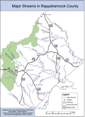
Map Number 1: Major Streams
The Rappahannock County Natural Resource Map Series is designed to assist citizens and leaders in Rappahannock County, Virginia, in understanding and making decisions about the uses and protection of natural resources in this scenic, rural area. Each map in the series addresses a separate theme, such as streams, subwatersheds, riparian buffers, water quality, topography, land cover and land use, land conservation, historic districts, and others.
The Major Streams map is designed to help citizens and visitors become familiar with the locations of the main tributaries, most of which have their headwaters within the County. The Hazel River subwatershed includes the Hazel, the Thornton, the Rush, the Covington, and the Hughes rivers. The Rappahannock River forms our northeastern border with Fauquier County. Its subwatershed includes the Jordan River, Indian Run, Hittles Mill Stream, Hickman Run, Thumb Run, and many smaller streams. The stream near your property flows into one of these major streams and rivers. Other maps in this series will show the extensive network of smaller streams for selected subwatersheds.
 |
Click on map for higher resolution image.
|
This Major Streams map was constructed using Geographic Information System (GIS) software and digital data from several sources, including the U.S. Environmental Protection Agency Reach Files. The names of streams vary depending on local terminology and state and federal sources of information.
This Rappahannock County Natural Resource Map Series is produced by the Piedmont Research Institute as a public service, with support from several organizations including the Rappahannock League for Environmental Protection, the Rappahannock County government, the Piedmont Environmental Council, Rappahannock Friends and Lovers of Our Watershed (RappFLOW), the Rappahannock County Conservation Alliance, and others. For more information about this map, please contact bev@piedmontresearch.org.
Map Number 1: Major Streams
(See RappFLOW Reports &
Publications: Air and Water Quality in the Shenandoah National Park)
Map Number 2: Streamside Vegetation
(See
Ways to Protect Our Watershed:
Streamside Vegetation)
Map Number 3: Thornton Upper
Watershed
(See Ways to Protect Our
Watershed: Stop Erosion Now!)
Map Number 4: Forests and Streams
(See Ways to Protect our
Watershed: Sustainable Forestry)
