Acknowledgements
This work was accomplished by volunteer citizen efforts, with financial help from several agencies and individual donors. Costs were covered in part by grants # 2006-0100-001 and 2005-0001-039 from the National Fish and Wildlife Foundation’s Chesapeake Bay Small Watershed grant program; and a grant from the Rappahannock-Rapidan Planning District Commission and Virginia DCR (2005).
RappFLOW[1] is a not-for-profit, grassroots, citizen-based organization whose work is accomplished by volunteers trained primarily by the Culpeper Soil & Water Conservation District. Many individuals and organizations contributed in a variety of ways to the work reported in this document. Greg Wichelns, Manager of the Culpeper Soil & Water Conservation District, has provided hundreds of hours of technical assistance, guidance and training in stormwater management, landscape and stream buffer assessment, water quality, erosion & sedimentation control, and many other technical topics.
John McCarthy, County Administrator, provided guidance and data on public policy, local and state regulatory issues, zoning, ordinances, and public outreach. Members of the County Board of Supervisors and the Planning Commission provided ongoing encouragement and guidance and suggestions for the ongoing research. County leaders who have encouraged and inspired this work over the years include Bob Anderson, Chairman of the Board of Supervisors, and his predecessor Pete Estes who shared with us his reverence for our county’s land, history and rivers. Charley Strittmatter, Chair of the Planning Commission, was part of the strategic planning group that challenged RappFLOW to produce a scientifically defensible description of the watersheds. Tom Tepper (Planning Commission), Bryant Lee (Board of Supervisors), Kenner Love (Agricultural Extension), Medge Carter (Dept of Health) and Reid Folsom (Agricultural consultant) have all contributed to this work in several ways over the past several years, including their participation in the County Water Quality Advisory Committee.
Ron Vickers, teacher at Rappahannock County High School (RCHS), with encouragement from the school system administration and the Virginia Department of Education, and professional assistance of Beverly Hunter, has trained dozens of students in technical skills related to the spatial analysis and mapping used in this work. Several RCHS students, notably Larry Oliver, Chris Mitchell, Donovan Zeh, Joshua Makela, Forrest Marquisee, John Mellow, Justin Fitzmorris, and Zach Herbert contributed to team projects or worked as summer GIS interns, helping to produce the maps and data provided with this report.
Several farmers in the County, especially Cliff Miller, Chris Parrish, Monira Rifaat, Elizabeth Haskell, Bryant Lee, and Robert Anderson helped in understanding factors affecting local agriculture and land management practices. Cliff Miller has generously contributed the use of his property for training of water quality monitors, public outreach activities, stream buffer restoration projects, and water quality studies.
Sarah Gannon, formerly with the Piedmont Environmental Council, and Jill Keihn a biologist from Page County, helped to devise the subwatershed delineation and assessment methods. Scientists at the Center for Watershed Protection assisted in developing our methodology.
Tim Bondelid, a professional hydrographer, has provided technical assistance in data analysis and the use of the National Hydrographic Dataset, as well as research and interpretation of scientific literature. Brett Valentine, President of RappFLOW and a soils scientist with Fauquier County, interpreted soils data. Jenny Fitzhugh gathered and organized dozens of documents for research and public education on topics of this report. Hal Hunter helped find and acquire data, handled logistical and administrative tasks, provided financial support, collaborated with partner organizations, and conducted research on easements and other conservation tools. Pam Owen of the Rappahannock League for Environmental Protection’s Biodiversity Task Force organized educational opportunities that help to inform the ecological perspective.
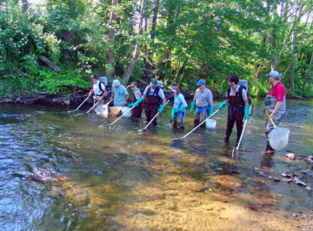
Kenny Giles, Christina Loock, and Louise Bondelid provided training and leadership for water quality monitoring volunteers, in cooperation with the CSWCD. Several individuals in the Virginia Departments of Environmental Quality (DEQ), Conservation & Recreation (DCR), and Forestry (DOF), and the Rappahannock-Rapidan Regional Commission (RRRC) have provided technical assistance, data, information on regulatory matters, and assistance in obtaining grant support for the work. These include most notably James Beckley and Bryant Thomas (DEQ), Mike Santucci (DOF), May Sligh (DCR), and Jeff Walker (RRRC). Several agencies have provided ongoing updates to key data sources, including the Virginia Outdoors Foundation (VOF), DCR, and DEQ and Trout Unlimited.
Todd Benson, John McCarthy, Dick McNear, Monira Rifaat, Brett Valentine, and Greg Wichelns all reviewed drafts of this report, but the author takes responsibility for any inaccuracies herein.