
Rappahannock Friends and Lovers of Our Watershed
How Healthy Are Our Watersheds?
Ways to Protect Our Watersheds
Stream Buffers
-Riparian Buffer & Rain Garden
-Buffer Handbook
-Sources of native plants
Upper Thornton River Watershed Study
RappFLOW is a member of the Orion Grassroots Network
An Overview of RappFLOW’s Pilot Monitoring Program
April 2006
RappFLOW’s mission is to preserve, protect, conserve, and restore water resources to Rappahannock County’s watersheds. Critical to this mission is to determine the quality of the surface waters.
As part of a pilot study for evaluating the health of Rappahannock County’s watersheds and surface waters, RappFLOW has chosen to focus on the Rush River and its tributaries in 2006. A segment of the Rush River (from river mile 4.23 at the confluence with Big Branch tributary to river mile 8.78 at the confluence of an unnamed tributary) is listed on the Clean Water Act 303d list as not supporting recreational use due to fecal coliform counts exceeding standards. A TMDL is scheduled for 2014 with evaluation starting in 2006. The source of impairment is unknown. In addition to the current bacterial contamination, a permit for a new waste water treatment facility is being considered by the DEQ for the town of Washington. The effluent from the proposed treatment plant would be discharged into the Rush River.
The pilot volunteer monitoring program is made up of three components: monthly monitoring of chemical, biological, and physical parameters; semi-annual or quarterly benthic macroinvertebrate sampling; and ongoing stream buffer and health evaluations.
Monthly Water Quality Monitoring
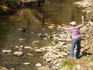 RappFLOW intends to sample at 10 locations on the Rush River. A small
group of trained volunteers will collect these samples at all sites once
a month (possibly excluding December and January). Sites were chosen
based on location of the impairment, areas of concern due to sewage in
Washington and the proposed treatment plant, and accessibility. Parameters
measured will include E. coli bacteria, dissolved oxygen, pH, transparency,
temperature, flow, total suspended solids (TSS), total phosphorus, and
ammonia. A commitment of one day a month for a year is required of volunteers.
RappFLOW intends to sample at 10 locations on the Rush River. A small
group of trained volunteers will collect these samples at all sites once
a month (possibly excluding December and January). Sites were chosen
based on location of the impairment, areas of concern due to sewage in
Washington and the proposed treatment plant, and accessibility. Parameters
measured will include E. coli bacteria, dissolved oxygen, pH, transparency,
temperature, flow, total suspended solids (TSS), total phosphorus, and
ammonia. A commitment of one day a month for a year is required of volunteers.
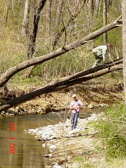
Benthic Macroinvertebrates
Aquatic life needs consistently healthy stream conditions so macroinvertebrates are good indicators of overall stream health, both short and long-term. The benthic macroinvertebrate surveys will be done by teams of 2-3 volunteers who are trained in the SOS (Save Our Streams) monitoring protocols. Each team will be responsible for one site and will complete the survey 2-4 times per year. This can be a great activity for families with older children. Volunteers must go through an in depth training and make a minimum commitment of two years.
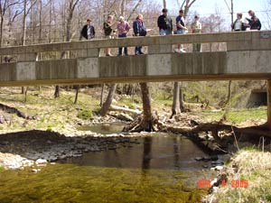
Riparian Buffer Evaluation/ Stream Observations
 Forested buffers along the streams and rivers are essential to healthy
waters. These buffers have numerous benefits including reducing erosion
and sedimentation, protecting against flooding, helping recharge the
groundwater, keeping some pollutants including nutrients, bacteria, and
chemicals from entering the water, creating fish habitat, and reducing
algae blooms. A long-term goal is to create a database of forested buffers
throughout the county. In April, a group of Rappahannock County High
School students will fine-tune a field methodology for evaluating buffers
and will create a GIS database that can be added to as more information
is collected. Volunteers from the community will be trained in the field
methods and add to the buffer database. Volunteers can evaluate riparian
areas of interest to them and at the request of other landowners.
Forested buffers along the streams and rivers are essential to healthy
waters. These buffers have numerous benefits including reducing erosion
and sedimentation, protecting against flooding, helping recharge the
groundwater, keeping some pollutants including nutrients, bacteria, and
chemicals from entering the water, creating fish habitat, and reducing
algae blooms. A long-term goal is to create a database of forested buffers
throughout the county. In April, a group of Rappahannock County High
School students will fine-tune a field methodology for evaluating buffers
and will create a GIS database that can be added to as more information
is collected. Volunteers from the community will be trained in the field
methods and add to the buffer database. Volunteers can evaluate riparian
areas of interest to them and at the request of other landowners.
Data collected by RappFLOW volunteers will be used for the following purposes:
-
Establish a baseline set of water quality and stream vegetative buffers data for the Rush River.
-
Identify possible sources of contaminants and evaluate their solutions
-
Raise awareness of water quality issues in Rappahannock County
-
Identify locations on the Rush River and its tributaries to be monitored in an ongoing monitoring program to measure long-term improvements in the water quality and stream vegetative buffers.
-
Provide data to the Culpeper Soil and Water Conservation District (CSWCD) to help them identify landowners that may be good candidates for cost-share incentive programs for installing BMPs (including stream vegetative buffers) and developing a land management plan.
-
Incorporate the data and associated maps into RappFLOW’s Upper Thorton watershed database.
-
Review and refine the protocols we use for training volunteers to make systematic observations of streams and buffer vegetation.
-
Refine methods for collecting, analyzing and interpreting measures of water quality, in preparation for an ongoing monitoring program in Rappahannock County.