
Rappahannock Friends and Lovers of Our Watershed
How Healthy Are Our Watersheds?
Ways to Protect Our Watersheds
Stream Buffers
-Riparian Buffer & Rain Garden
-Buffer Handbook
-Sources of native plants
Upper Thornton River Watershed Study
RappFLOW is a member of the Orion Grassroots Network
Rappahannock County watershed study underway
By Don Audette
03/23/2005
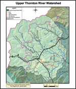 |
| Map created by Beverly Hunter of the Piedmont Research Institute |
When 400,000 tons of rain-soaked soil traveled down a 35-degree slope
onto the small seaside town of La Conchita, CA, on January 10, 2005,
people saw a watershed in extreme action. After a prolonged period of
rain, earth and rock started down the 600-foot bluff behind the town
at about 20 miles per hour. The on-rush destroyed 13 homes and seriously
damaged 23 others out of about 200 in the town at the foot. Ten people
were killed.
Ten years ago this summer, on June 27, 1995, Madison County, just south of Rappahannock County, received 30 inches of rain in 16 hours. According to the U.S. Geological Survey, one rain-soaked landslide near Graves Mill, Virginia, "traveled nearly 2 miles, and an eyewitness estimated that it moved at a speed approaching 20 miles per hour." You can still see the scars on the mountains above Criglersville and Graves Mill. Another watershed in extreme action.
Normally, though, watersheds are benign. Ordinary rain and snowmelt flow gently down slopes to creeks and streams in valleys and then to rivers and eventually, in this area, to the Chesapeake Bay. The water also soaks into the earth, traveling downward into the ground, replenishing well water. But at times of prolonged or intense rain, water may move laterally underground, moving earth above it as if on a watery toboggan. Building on steep slopes and clearing groundcover obviously carry some risks.
Almost everyone in Rappahannock County can observe a mini-watershed on his or her property. A driveway especially can teach you about the activities of a watershed better than any other medium. You observe it almost every day. After a heavy rainfall, those with a gravel driveway may observe gullies crisscrossing their driveway, with piles of gravel fingered out along the edges. Others may see soil from their driveway washed out onto a highway. Some ignore their driveways after repeated rains and snowmelts, and watch as their driveway is reduced to its foundation rocks. Your own mini-watershed may also exhibit soil erosion on other sloping areas, with tree roots and rocks becoming more and more exposed.
A river runs through it
With all this activity going on day after day, year after year, and generally unobserved, some Rappahannock County people and others have gathered together for an interesting project. In the vicinity of Washington and Sperryville lies the Upper Thornton River watershed. The group has selected a specific segment of roughly 100 sq. miles there to carry out a pilot project involving a detailed analysis of its water (see map). If the analysis proves useful, the idea may be extended to the rest of Rappahannock County.
The reasons for selecting the Upper Thornton River watershed are as follows:
-
The area includes part of the Shenandoah National Park, where the watershed starts.
-
A wide variety of land uses are covered -- forest, agriculture, residential, and commercial -- as well as large and small landowners, old and new homes, and a topographical mix ranging from steep slopes to a flood plain. The area also includes examples of the Conservation Reserve Enhancement Program (CREP) and Best Management Practices (BMP).
-
The area includes the only existing wastewater treatment plant in Rappahannock County (Sperryville); and the Town of Washington is planning both a new water treatment plant and wastewater treatment plant.
-
Both Sperryville and Washington are among the village growth areas designated in the Rappahannock County Comprehensive Plan. The watershed also includes the Commercial Area Plan for the county, along Rt. 211 between Washington and Sperryville.
-
The area includes Rappahannock County's only two water segments currently designated as being impaired by the Virginia Department of Environmental Quality (see map).
Time well spent
There is something fascinating about taking a small piece of the earth and studying it intensely. Ultimately, the purpose is to help individual landowners make decisions on how to better manage their land to protect their watershed.
The proposed study will take about a year and a half to complete, with the aim of preserving, protecting, and restoring the water quality of the Upper Thornton River watershed. As noted, the result of the approach may be used on other watersheds in the county. It is expected that the project findings will also help support local decision-making in regard to larger goals such as those of the Chesapeake Bay 2000 agreement.
One objective of the project neatly sums up the complexity of the undertaking - the creation of cross-referencing matrixes that integrate and tie together the following: "scientific, social, educational, economic, engineering, and political aspects of watershed management in ways that work for our people, topography, cultures, land uses, land cover, economy, and political processes."
Contributions and volunteers from 18 organizations are working on the project under the leadership of the Rappahannock Friends and Lovers of Our Watershed (RappFLOW). These include the Shenandoah National Park, the United States Department of Agriculture's National Resource and Conservation System (USDA-NRCS), the Rappahannock League for Environmental Protection (RLEP), the Rappahannock County Conservation Alliance (RCCA), the Rappahannock County Health Department, the Piedmont Environmental Council (PEC), the Hearthstone School, the Virginia Department of Forestry, the Culpeper Soil and Water Conservation District, and eight other organizations.
The payoff? The cleaner and more undiminished the water leaving Rapppahannock County, the more interested counties downstream will be in seeing that Rappahannock County is not over-developed. This could conceivably include monetary contributions from downstream counties.
For example, New York City has a multi-million dollar program to protect its rural watersheds north and west of the city. Something akin to that program might be used for Rappahannock County in the future.
To join the study group, or obtain more information, please see the
new RappFLOW web site at: http://www.rappflow.org .
©Times Community Newspapers 2005