Lower Hazel/ Muddy Run/ Indian Run
Upper Rappahannock/ Jordan & Subwatersheds
Lower Thornton & Subwatersheds
Upper Thornton & Subwatersheds
| 100 Foot Stream Buffers | Subwatershed Scores | |||
|
||||
The RappFLOW Survey 2006
Status of Upper Thornton Survey March 8, 2006
On January 30, 2006, RappFLOW volunteers mailed 1500 surveys to all known addresses of residents and landowners in the Upper Thornton River Watershed, identified by one of thirteen subwatersheds. Respondents were offered a free aerial photo of their property as an incentive to return the survey.
As of today we have received 150 filled-in surveys and about 400 envelopes returned for incorrect address.
We have received 80 requests for the aerial photo. Two classes of GIS students at RCHS are making the aerial photos under the instruction of Beverly Hunter, Ron Vickers, and Larry Oliver. About 70 of these requests have been filled to date.
The first 150 surveys represent almost 10,000 acres of land. Respondents own or live on parcels from the size of a lot to over 1,000 acres.
The first 150 respondents answered question 7 in the following way:
Question 7: Three water issues that concern me the most are the following:
Answer choice |
# out of 150 choosing |
b. quality of well water |
91 |
a. adequate supply of good drinking water |
79 |
h. bacterial contamination of stream water |
55 |
g. trash in the streams |
38 |
l. need to help clean up the Chesapeake Bay |
34 |
j. nutrients (nitrogen and phosphorus) in streams and ponds |
30 |
f. stream bank erosion |
29 |
k. loss of fish species in waterways |
24 |
e. sediment in streams and ponds |
18 |
d. floods |
17 |
c. sufficient water for livestock |
13 |
i. algae in ponds |
7 |
Preliminary Comments: Quality and/or quantity of drinking water is the most important issue to the most people, possibly a strong motivator for actions such as improved land management practices. Need to clean up the Chesapeake Bay is a strong concern of 34 out of 150 respondents.
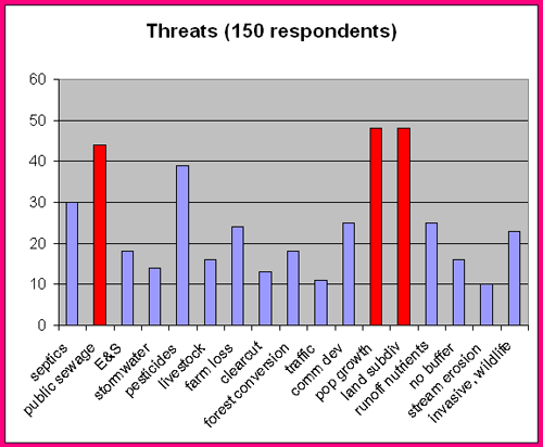
The first 150 respondents answered question 8 as follows:
Question 8:Three threats to my watershed that concern me the most are:
|
l. population growth |
48 |
m. subdivision of land parcels |
48 |
b. public sewage treatment plant discharge to stream |
44 |
e. pesticides and herbicides |
39 |
a. septic tanks & other private sewage disposal |
30 |
k. commercial development |
25 |
g. loss of farms |
24 |
s. invasive species |
20 |
n. agricultural runoff (nutrients) |
20 |
i. conversion of forests to other land uses |
18 |
c. erosion and sedimentation from driveways and private roads |
18 |
f. livestock in streams and ponds |
16 |
p. lack of forested buffers along streams and ponds |
16 |
d. stormwater runoff |
14 |
h. clear cutting of forests |
13 |
j. traffic |
11 |
q. stream bank erosion |
10 |
o. residential runoff (nutrients) |
5 |
r. wildlife in streams and ponds |
3 |

Preliminary comments: 1) Since lack of forested buffers is of major concern to only 16 out of 150 respondents, there is a major opportunity for education regarding the relationships among riparian buffers and those issues that most concern people, namely clean and plentiful drinking water and bacterial contamination of stream water. 2) The major concerns about population growth and land subdivision provide good opportunities for public education about conservation tools such as easements. 3) The major concern about public sewage treatment plant effluent to stream, in contrast to low concern about lack of riparian buffers, provides good opportunities for education regarding STP effluent versus impact of land use practices.
Click on the map for your watershed, or use the link on the left.
Using the menu at the top will give you maps as indicated and as available. The links below contain information on your watershed.